| filebase | forums | discord | server | github | wiki | web |
| cubebot | epodbot | fritzbot | gravebot | grogbot | hpbbot | ivpbot | jkbotti | joebot |
| meanmod | podbotmm | racc | rcbot | realbot | sandbot | shrikebot | soulfathermaps | yapb |


Google Earth |

|

|
(#1)
|
|
Yeah, right.

Status: Offline
Posts: 848
Join Date: Jun 2004
Location: Rio de Janeiro - Brazil
|
Have you seen Google's new gadget? It's called Google Earth... You download the program and you get to see many towns from pictures taken by planes and sattelites. It's very interactive, not just a lot of folders with the photos (in fact, google's server streams them to you when you need them)
I'm putting some samples here, so you can see what I mean  Yay, South America!  Yay, Rio de Janeiro!  My old school... Yeah, the pool, 3 courts (+a covert gym) and the building. Not that big one on the left, the one with the grey roof, kinda "L"-shaped. All surrounded by trees in the middle of the downtown   Brasilia, our capitol city. You can notice that it is kinda shaped like a plane. That is on purpose. It was built in the 1960s, under the government of Juscelino Kubitschek (J.K. is more simple) in the middle of the country, many say, because in the case of an invasion, Rio de Janeiro (the former capitol) would be too vulnerable, because it is in the coast.  Vatican City. From the air, you can notice the "key" shape of it.  von Ryan, pwning Combine Dropships since 2005
|
|
|

|
Re: Google Earth |
|
|
|
(#2)
|
|
One Eyed Freak

Status: Offline
Posts: 1,164
Join Date: Dec 2003
Location: local mall
|
ive got another app.. but is constructed by nasa.. nasa got detailed of few big cities..but its getting bigger..
they got not so detailed overlay for the whole world.. but if you relaly want to zoom in something you need to do that on cities like washington dc.. still you i can se where my town is.. dont have a link.. or even the real name for it since it was awhile i saw it..   |
|
|
|
Re: Google Earth |
|
|
|
(#3)
|
|
Council Member, Author of JoeBOT

Status: Offline
Posts: 1,381
Join Date: Nov 2003
Location: Germany
|
maybe you are referring to http://worldwind.arc.nasa.gov/ ? the normal resolution is worse than the google stuff, but the black and white usgs data is ~1m resolution I think, too

|
|
|
|
Re: Google Earth |
|
|
|
(#4)
|
|
Failed student

Status: Offline
Posts: 640
Join Date: Dec 2003
Location: Plymouth (No longer!)
|
Don't have the bother to d/l now, I'm off for the month tonight.
Does it have Church Crookham, Fleet, HANTS, England on it? If so, naughty naughty! I'm not so sure now, but it used never to be on these sort of things. (Military installation.) What about Aldershot? Brother Boot Knife of Quiet Reflection The following errors occurred when this message was submitted:
|
|
|
|
Re: Google Earth |
|
|
|
(#5)
|
|
RealBot Author

Status: Offline
Posts: 3,088
Join Date: Nov 2003
Location: Netherlands
|
Downloaded it. Its quite cool.
When you go to Amsterdam Central Station.... you see my pitstop every day  |
|
|
|
Re: Google Earth |
|
|
|
(#6)
|
|
Council Member, Author of JoeBOT
Status: Offline
Posts: 1,381
Join Date: Nov 2003
Location: Germany
|
fuckin' drug addict
|
|
|
|
Re: Google Earth |
|
|
|
(#7)
|
|
Best served chilled

Status: Offline
Posts: 1,005
Join Date: Dec 2003
Location: Saskabush, Canuckada
|
..Wow, this is awesome!
  |
|
|
|
Re: Google Earth |
|
|
|
(#8)
|
|
One Eyed Freak
Status: Offline
Posts: 1,164
Join Date: Dec 2003
Location: local mall
|
downloading.. need to compare..
|
|
|
|
Re: Google Earth |
|
|
|
(#9)
|
|
Roi de France

Status: Offline
Posts: 5,049
Join Date: Nov 2003
Location: 46°43'60N 0°43'0W 0.187A
|
Scary indeed...
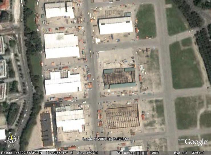 Munich! The building of the tents for the oktoberfest !!! RACC home - Bots-United: beer, babies & bots (especially the latter) "Learn to think by yourself, else others will do it for you." |
|
|
|
Re: Google Earth |
|
|
|
(#10)
|
|
|
Summoner

Status: Offline
Posts: 1,499
Join Date: Feb 2004
Location: Mist Village
|
from their stupid EULA:
Quote:
|
|
|
|
|
 |
«
Previous Thread
|
Next Thread
»
| Currently Active Users Viewing This Thread: 1 (0 members and 1 guests) | |
|
|

Powered by vBulletin® Version 3.8.2
Copyright ©2000 - 2024, Jelsoft Enterprises Ltd.
vBulletin Skin developed by: vBStyles.com
Copyright ©2000 - 2024, Jelsoft Enterprises Ltd.
vBulletin Skin developed by: vBStyles.com